Geomatics & Information Systems

Your strategic multisector partner for your projects

DSN SARL, an Ivorian company, supports you in cartography, GIS, remote sensing, topography and the distribution of high-precision geodetic equipment.

10+ Years of Experience
50+ Completed Projects
80+ Satisfied Clients

About Us

DSN SARL is an Ivorian company specialized in geomatics and information systems, based in Abidjan. We support public institutions, international organizations and the private sector in their projects related to spatial and geographic data management.

Our expertise covers digital cartography, GIS, remote sensing, precision topography and distribution of high-performance geodetic equipment. We combine technical rigor and innovation to deliver quality products across West Africa.

10+

Years of Experience

50+

Completed Projects

80+

Client Satisfaction

15+

Collaborators

DSN SARL
10+

Years of Expertise

Services

Complete geomatics solutions to meet your cartography, GIS and information systems needs
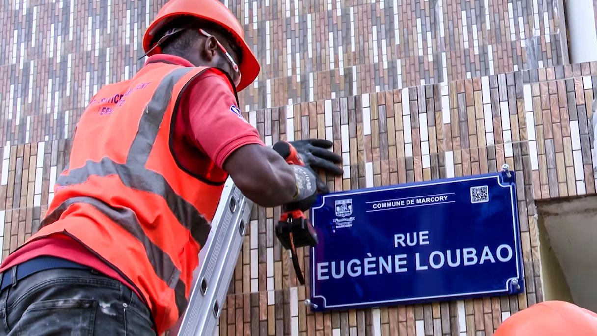
Utility Network Mapping

Comprehensive mapping of underground and overhead utility networks: water, electricity, gas, sewerage, telecommunications. GIS integration for optimal infrastructure management.
Learn More

Traffic Studies & Spatial Analysis

Road traffic and urban mobility studies: traffic counts, origin-destination surveys, flow modeling and recommendations for transport optimization.
Learn More

Land Use Planning

Cartographic production and urban planning documents: master plans, urban development plans, environmental impact studies, territorial modeling and digital twins.
Learn More

Geodesy & GNSS Stations

Deployment and management of permanent GNSS reference stations, high-precision topographic and geodetic surveys, RTK positioning and geodetic equipment supply.
Learn More

GIS Databases & Business Solutions

Geographic database design, WebGIS platform development, custom mobile applications and business solutions for urban planning, transport and the environment.
Learn More

GIS Data Production & Sales

Production and sales of geospatial data: high-resolution orthophotos, digital terrain models, utility network data, 3D urban databases and NTRIP services.
Learn More

Need geomatics expertise?

Contact us to discuss your project and get a personalized quote.

Request a Quote

Our References

Discover our achievements in cartography, GIS, remote sensing, traffic studies and civil engineering

Traffic Studies Ongoing

Intelligent Transport System for Greater Abidjan – JICA

Support for implementing an integrated and sustainable urban transport system in Greater Abidjan. GPS data collection and travel speed monitoring syst...
AMUGA / Nippon Koei / JICA 2026-2029
Greater Abidjan, Ivory Coast
Intelligent Transport System for Greater Abidjan – JICA
Urban Addressing Ongoing

PADA Catch-up – Addressing of the Autonomous District of Abidjan

IT component update for the address assignment project for buildings and roads in the Autonomous District of Abidjan. Design and implementation of a r...
Ministère de la Construction, du Logement et de l'Urbanisme (MCLU) 2025-2026
Abidjan, Ivory Coast
PADA Catch-up – Addressing of the Autonomous District of Abidjan
Urban Addressing Ongoing

PAVI – Addressing of Yamoussoukro, Daloa and Korhogo

Execution of the IT component for the address assignment project for buildings and roads in interior cities of Ivory Coast. Design and implementation...
MCLU 2025-2026
Yamoussoukro, Daloa, Korhogo, Ivory Coast
PAVI – Addressing of Yamoussoukro, Daloa and Korhogo
GIS DB & Solutions Ongoing

SYGIDAN-GEO – Taxpayer Georeferencing

Implementation of a georeferenced taxpayer system (SYGIDAN-GEO) in the municipalities of Abobo, Anyama, Adjamé, Treichville and Yopougon. Relational d...
Ministère de l'Intérieur et de la Sécurité / Défis & Stratégies 2025-2026
Abidjan, Ivory Coast
SYGIDAN-GEO – Taxpayer Georeferencing
Equipment Supply Completed

Supply of 10 Mini-RTK Units to BNETD

Supply of ten (10) Mini-RTK units with permanent license and SurPro 6.0 software to the National Bureau of Technical Studies and Development.
BNETD 2025
Abidjan, Ivory Coast
Supply of 10 Mini-RTK Units to BNETD
Cartographic Production Completed

DUP Urban Unit 9 – Alépé and Bonoua

Detailed urban plans: VHRS satellite imagery acquisition, AI-based building extraction, point cloud creation and contour modeling, QField tools supply...
MCLU / Groupement AFRICURBA, EUE, 2AUT 2023-2024
Alépé, Bonoua, Ivory Coast
DUP Urban Unit 9 – Alépé and Bonoua

Our Partners

Public institutions, international donors and leading private actors: DSN supports major organizations in their geospatial projects.

République de Côte d'Ivoire République de Côte d'Ivoire
Banque Mondiale Banque Mondiale
JICA JICA
MCLU MCLU
AGEROUTE AGEROUTE
CC-PTUA CC-PTUA
Port Autonome d'Abidjan Port Autonome d'Abidjan
BNETD BNETD
CAPEC CAPEC
CI-ENERGIES CI-ENERGIES
CIE CIE
AUGVIEW AUGVIEW
Groupe Défis & Stratégies Groupe Défis & Stratégies
NEC Corporation NEC Corporation
Oriental Consultants Oriental Consultants
Urbaplan Urbaplan
α-GEO α-GEO
Orange Orange
Tony's Chocolonely Tony's Chocolonely
ECOFOR ECOFOR